

Democratizing RTK End-to-End: Infrastructure Meets Cloud Processing for Cost-Effective Centimeter Level Positioning
Democratizing RTK End-to-End: Infrastructure Meets Cloud Processing for Cost-Effective Centimeter Level Positioning
High-precision GNSS positioning has historically suffered from a major barrier to entry.
If you wanted centimeter-level accuracy, the rules were simple: you had to invest in costly hardware, expensive infrastructure, and high subscription fees. For many applications, across IoT, robotics, fleet tracking, and beyond, this setup is simply not viable due to complex integration, strict cost structures, power consumption constraints, and heavy hardware demands.
That landscape is changing fast.
True democratization of high precision requires solving both sides of the equation: infrastructure and device-side processing.
- On the infrastructure side, onocoy is disrupting the status quo by building a decentralized, community-driven RTK caster network, making high-quality, real-time correction data universally accessible.
- On the device side, Tupaia is shifting the heavy lifting off the hardware towards the cloud. By processing raw GNSS measurements through Tupaia’s cloud engine, standard receivers can achieve precision positioning without needing expensive chips or specialized onboard firmware.
When you connect onocoy’s open infrastructure directly to Tupaia’s cloud engine, the entire economics of precision positioning change. To prove what this end-to-end combination can do, we put three standard receivers, and an everyday smartphone, through a series of static and real-world dynamic stress tests.
Here is what happens when decentralized correction data meets cloud-based precise-positioning.
The Test Architecture: Connecting Cloud & Caster
To test what happens when democratized infrastructure meets a cloud-native precise-positioning service, we set up a streamlined, direct integration.
How the Data Flows
The pipeline is designed around a simple API connection that offloads computation from the edge to the cloud:
- The Infrastructure Layer: For our RTK reference station, we used a Tupaia reference station powered by a Dual-Frequency (L1 & L5) receiver. This single station generated the correction stream for all three test devices and our Android smartphone, streaming real-time observation data straight into onocoy RTK caster network.
- The Cloud Layer: Tupaia’s cloud service subscribes to these onocoy caster streams via standard network protocols, pulling raw correction data directly into our processing engine.
- The Edge Layer: In these tests we employed standard GNSS receivers, that continuously uploading their raw GNSS measurement streams over a lightweight data pipe to Tupaia’s cloud API. This comes instead of forcing edge hardware to process heavy positioning algorithms locally. Tupaias’ cloud precise positioning engine computes the precise position resolution in real time and delivers high-accuracy coordinates back to the device.
The Hardware Lineup
We selected standard, off-the-shelf receivers with different signals support and from different vendors to showcase the capabilities of this new proposed paradigm:
- Vendor A Dual-Frequency (L1 & L5): A standard dual-band receiver commonly found in modern devices and tracking applications.
- Vendor A Single-Frequency (L1): A basic, ubiquitous single-frequency receiver used widely across mass-market IoT devices.
- Vendor B Dual-Frequency (L1 & L5): A standard, cost-effective dual-band module used among IoT vendors.
With the architecture connected and the hardware selected, we put the entire pipeline through two rigorous benchmarks: a static baseline test and a multi-environment dynamic drive test
Benchmark 1: Static Tests – Pinpoint Precision
To evaluate performance, we mounted our test units in a controlled static environment to measure convergence times, fix-rate, and baseline accuracy.
Key Results
- Instant Convergence (1–3 Epochs): All receivers were positioning locked almost immediately by Tupaia. Convergence time depends on initial raw signal density (a hardware-dependent factor) showing that once initial measurements flow, Tupaia’s engine resolves positions in seconds.
- Above 99.99% Fix Rate: Offloading position calculation to Tupaia’s cloud maintained rock-solid service stability over the stream connection.
- Sub-Centimeter Horizontal Accuracy: All three standard receivers achieved sub-centimeter horizontal precision, proving cloud engine capability neutralizes edge hardware limitations.
- Vertical Accuracy: Scaled smoothly based on hardware class and frequency: Vendor B (L1 & L5) ~1 cm, Vendor A (L1 & L5) ~3 cm, Vendor A (L1) ~5 cm.
The Takeaway: Even standard single-frequency hardware reaches an accuracy of a few centimeters, while standard dual-frequency setups break into true centimeter-level precision.
Benchmark 2: Drive Tests – Real-World Dynamic Test
To test dynamic tracking, we mounted all three receivers to a vehicle and hit the road for a drive test across a demanding mixed environment: tight urban canyons, suburban streets, and high-speed highways.
Key Result
- Decimeter-Level Precision on the Move: All three standard receivers consistently maintained 10-15 cm accuracy or better throughout the majority of the drive. Even under dynamic motion and changing satellite visibility, Tupaia’s cloud engine kept trajectory tracks tight and reliable.
- High Dynamic Fix Rates: The system maintained an high fix-rate across the test: Vendor A (L1 & L5) 95%, Vendor A (L1) 87%, Vendor B (L1 & L5) 80%.
Several snapshots from the drive-test of three different environments, Vendor A L1&L5 in Yellow, Vendor A L1 only in Green, and Vendor B L1&L5 in Red.
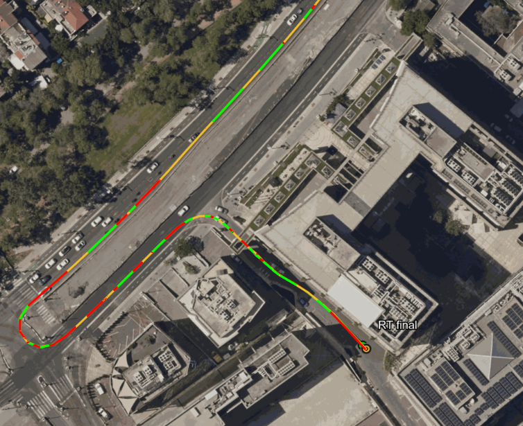
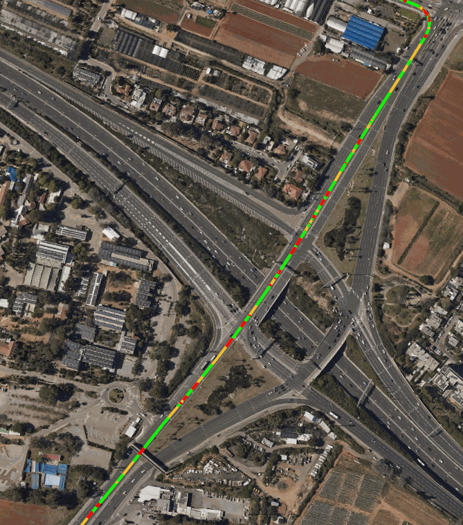
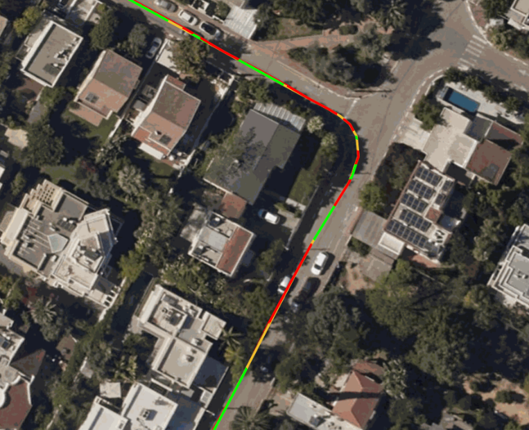
The Takeaway: Continuous centimeter-to-decimeter positioning accuracyduring real-world driving isn't reserved for multi-thousand-dollar RTK setups anymore. Tupaia's cloud-based engine processing keeps standard receivers locked on target, even at highway speeds and through urban environments.
Conclusion: End-to-End Democratization in Action
This joint benchmark demonstrates that high-precision GNSS positioning no longer requires high-cost dedicated RTK hardware or network.
By shifting heavy computational positioning algorithms off edge hardware into Tupaia’s cloud service, standard receivers alongside everyday smartphones, can achieve centimeter-level accuracy without the hardware costs, power draw, and integration complexities of traditional RTK setups. This shift unlocks mass-market scalability for applications across IoT, micro-mobility, autonomous delivery, robotics, and mobile workforces.
Pairing Tupaia with onocoy’s decentralized RTK caster network establishes a fully open infrastructure model. It provides unprecedented deployment flexibility on the correction side, removing dependence on expensive, closed proprietary base station networks.
For existing onocoy network users and data providers, as well as other RTK networks, integrating with Tupaia instantly broadens support to a vast range of standard, off-the-shelf device hardware. It extends the reach of onocoy’s streams to whole new device categories, hardware types, and high-precision use cases that were previously priced out of RTK performance.
Ready to bring high precision to your existing hardware? Explore Tupaia's Cloud Engine or connect with our team.